Max. Elevation







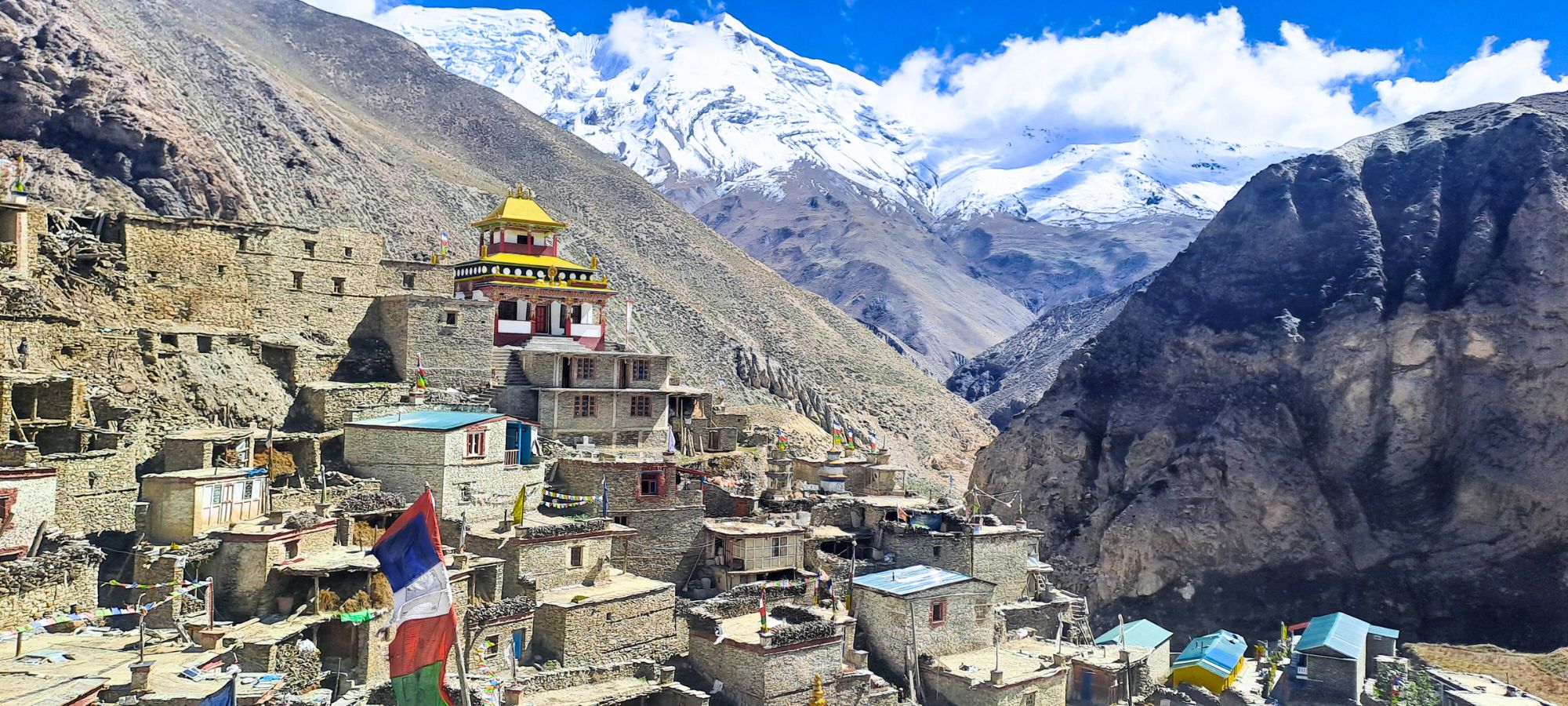
The adventure begins in the restricted Nar Phu Valley, a remote region strongly influenced by Tibetan culture and untouched alpine wilderness. Trekking through deep gorges, pine forests, and wide yak pastures, the trail leads to traditional villages, ancient monasteries, prayer walls, and stone-built settlements that reflect a timeless mountain lifestyle. Towering peaks such as Kang Guru, Pisang Peak, and Himlung Himal dominate the skyline as the route gradually gains altitude.
One of the major highlights of the trek is the crossing of Kang La Pass 5320m, which connects Nar Phu Valley with the Annapurna region. The ascent to Kang La is steep and demanding, involving snowfields and rocky terrain, but the reward is exceptional panoramic views of Annapurna II, Gangapurna, Tilicho Peak, and the surrounding glaciers. The descent leads towards the Manang area, offering a striking contrast between the isolated Nar Phu Valley and the more open alpine landscapes of Annapurna.
Beyond Manang, the route turns north again toward Tilicho Lake, becoming increasingly remote. From here, the trek enters a truly wild section with two nights of camping at Eastern Camp and Chaurkharka. These high-altitude camps are set in rugged alpine terrain with no lodges, providing a genuine expedition-style experience. Camping in these remote locations allows for proper acclimatization and preparation for the second high pass while enjoying silence, star-filled skies, and dramatic mountain scenery.
Crossing Mesokanto La Pass 5,300m is the ultimate challenge of the journey. The climb involves steep moraine, loose scree, and possible snow conditions, demanding good fitness and mountain experience. From the summit, trekkers are rewarded with breathtaking views of Tilicho Peak, the Annapurna massif, and vast glacial landscapes before descending to the spectacular Tilicho Lake (4,919m), one of the highest lakes in the world.
Ideal for strong and experienced trekkers, this journey combines cultural immersion, two high Himalayan passes, remote camping, and one of Nepal’s most iconic alpine lakes. The Nar Phu Valley Kangla to Tilicho Lake and Mesokanto La Pass Trek offers a rare, challenging, and unforgettable Himalayan adventure far from the crowds.
Upon your arrival in Kathmandu, our local team warmly welcomes you at the airport. You will then be escorted to the hotel, where you can enjoy some well-deserved relaxation. The itinerary includes a briefing about the trek's progress and presentation, followed by leisure time. If you arrive in the morning, you'll have the entire day at your disposal. This can be used for rest or for those interested, to explore the surroundings freely. It's an ideal chance to deeply experience Nepalese culture and indulge in the local culinary delights.
Have breakfast and then you have the whole day to explore the best Kathmandu Sightseeing spots with your guide. You can visit and explore one of the most famous Shiva temples, Pashupatinath, recognized as the monkey temple; Swyambhunath, the largest Stupa in the world, also called Boudhanath Stupa; and finally the Royal Palace, Kathmandu Durbar Square. The next day, you will begin your trek on the Annapurna Circuit, so you have to check your equipment to make sure that you are ready for your adventure and climb. Have dinner and stay overnight in the same hotel in Kathmandu
We leave by bus for Dumre, 130 kilometers from Kathmandu, on the road to Pokhara. The road offers magnificent views of the Trisuli river valley, then we cross superb tropical landscapes, before going up towards Dumre and having a first vision of the Annapurnas and Machhapuchhare. From there, we continue towards the north, up to Besi Sahar, by a track that curves in the middle of the rice fields. Then, we take a Jeep to reach Jagat, the starting point of our hike.
The Marsyangdi River rumbles at the bottom of its gorges, forcing us to cross some beautiful suspension bridges. Just before Tal, the valley suddenly opens up, and we can admire the Manaslu (8,163 m). After an ascent along the cliffs, we reach Dharapani by another suspension bridge. We are now in a Buddhist country, which was part of the Gyasumdo region, whose center was Manang, and which traded a lot with Tibet.
The path bends sharply towards the west to enter a valley where the vegetation becomes alpine with pines and junipers replacing the virgin forest. We change the level of vegetation. We start trekking at Dharapani. After an hour's walk, we arrive at the village of Bagar chap; a little further, we discover our first "8000"; prayer walls and gompas. In Koto, Annapurna II and Manaslu are in focus.
We leave for the first time the traditional classical trek of the Annapurna, which continues its way towards the west, to engage in a narrow valley to the north, leading to the Tibetan border. From now on, there is a basic lodge or tea house, and the trip takes on a wilder dimension. We will follow the Naar Phu River, with its wooded banks, crossing it and recrossing it before setting up our camp in Meta Village.
We leave for the first time the traditional classical trek of the Annapurnas, which continues its way towards the west, to engage in a narrow valley to the north, leading to the Tibetan border. From now on, there is a basic lodge or tea house, and the trip takes on a wilder dimension. We will follow the Nar Phu River, with its wooded banks, crossing it and recrossing it before setting up our camp in Meta Village.
Gradually, we have a clear view of the summit of Kang Guru to the east (6,981 m) and that of Pisang to the west. After an imposing chorten, which marks the entry into Buddhist country, the path rises to reach the village of Meta, built on a plateau. The trail stays high above the river, passing through several hamlets until reaching the Kharka of Junam Goth, We continue on stony moraines before crossing the summer village of Kyang. Then we take a path carved into the cliff at a good height of the river which is now called the Phu Khola. Beyond this rather impressive passage, a course in level curve allows us to find the bed of the river and reach Phu Gate (the door of Phu) which we cross by taking a path in tight zigzags. Behind this passage, we enter an altitude mineral valley in which Buddhist chörtens are placed here and there, reminding us that the inhabitants are of Tibetan origin. We land at the foot of the village on the superb campsite before going to visit this astonishing village with its houses lined up in an arid comb at different levels on the terraces.
We redo the opposite path until we come to the sight of Meta and we spin full slope in a sandy descent to join the river. We cross it on a footbridge over a deep gorge where tons of water rush. The camp is on the right bank halfway up the hillside in the middle of a grove of junipers.
We will go up to the mountain pastures which precede the village of Naar and pass in front of an imposing series of chortens and mani walls. You still have to be careful of the solitary yaks grazing in these wide open spaces and be as humble as possible when going around them.The path now rises to reach a ridge and a high plateau where the village of Naar is spread out. Visit the Tibetan village.
Long and splendid day. The path crosses a detrital shoulder before evolving well above the river on a “Nepalese flat”. Then it bends to the south to reach the Kang Pass. From the pass, the view is breathtaking on (almost…) all the Annapurnas (II at 7,939 m, IV at 7,525 m, III at 7,555 m) and the Gangapurna. The descent on the other side is steep towards the village of Ngawal, first in a moraine then in grassy slopes until Ngawal village.
A milder day begins with a beautiful forest path, on a balcony above the Marsyangdi River, before reaching the village of Munje. From now on, the valley is wide, the path flat until the beautiful village of Braga, with its terraced houses, dominated by its very old Gompa. We finally arrive at the Tibetan village of Manang, the capital of this small region. This village, at the confluence of two valleys, and framed by several mountain ranges, enjoys an exceptional location. Magnificent and varied views of many Himalayan peaks and their frozen waterfalls.
In Manang, we find the traditional way of the Turn of Annapurna but it is for immediately leaving it. Here begins our second detour, which will take us to Jomsom, via an altitude path. While the classic path follows the banks of the Jharsang Khola River, to then cross the pass of Thorong at 5,416 meters, we will reach the moraine lake, at the bottom of the north face of Gangapurna (7,454 m) before climbing gradually to the village of Khangsar. The last of our route before Jomsom. From the village, very beautiful view, especially on the Tarke Kang (7,202 m). Continuation to the base camp of Tilicho by taking a path traced on the side in sandy slopes.
Now, we are walking in the footsteps of Herzog's expedition in 1950, when they were looking for an access route to reach the foot of Annapurna I. They were the first to reveal the existence of the huge lake that stretches at the foot of the Tilicho peak (7,134 m), which they also named "the great barrier", the huge wall that stretches between the Roc Noir (7,485 m) and the northern summit of the Nilgiri (7,061 m). This name imposed itself on the expedition when it became obvious that no passage would be possible through this wall, to reach the slopes of Annapurna I. For two days, we will remain at high altitudes, at most near the summits, on paths that can be covered in snow. This evening, the view from our camp will look down over the Tilicho Lake scoop dominated by the glacial faces of Tilicho Peak.
We cross a first pass at 5,345m before embarking on a long crossing of an often snow-covered plateau to a sign indicating the direction of Mesokanto La. We discover the first surprise of the day, namely that we will have to cross a second pass that you reach by crossing using a small path on the side of the screen in almost a contour line. Then, it's a "flat Nepalese" path that will take us to the very end of a ridge where we will cross the Muktinath Himal chain via the Mesokanto pass at 5,100 m. On the other side, at the very bottom of the valley, you can make out the wide bed and the winding meanders of the Kali Gandaki. In the sky, the peaks of Tukuche (6,920 m) and Dhaulagiri, one of the most aesthetic 8,000m, stand out, while to the north, the brown peaks herald Mustang, Dolpo, and Tibet.
The descent is a bit long, but first, you will have to carefully descend the first meters of a snowy slope that is sometimes frozen below. At the bottom, we cross the torrent to go up to a rocky ridge from which we overlook green mountain pastures. We even distinguish the kharka that will welcome us this evening. The only downside: the path takes its ease to lead us there, and we arrive almost at nightfall.
Last day of walking, all downhill, to reach the large town of Marpha, a village surrounded by many orchards where the succulent Mustang apples are grown. Here, in the furrow of the Kali Gandaki, a priori the deepest valley in the world (practically 6,000 m between the peaks of Annapurna I and Dhaulagiri I) often swept by a violent wind. Last captivating summit: the north face of the Nilgiri (7,061m), covered with draperies of ice. "Trek is over…"
We end this superb trek by descending by bus to the impressive gorges that the Kali Gandaki has dug. In Beni, the tar continues the journey to Pokhara for a much-appreciated gluteal rest.
by private vehicle and ( optional domestic flight, extra cost 110 USD )
Free time depending on the departure time of your flight and our representative will drop you at the airport, ending your journey in Nepal. We hope to be of service to you again. Thank you and safe travels.
 Note:
Note:
If you have a private group and prefer a personalized experience, we can organize a custom trip tailored to your requirements and group size, running it any day you choose.
Plan a Private TripEach trekker is allotted the following maximum weights per person :For Lodge (tea house) Accommodations Trek:15 kg maximum;
Tent Camping Trek: 22 kg maximum; Expeditions/summit ascents: 20 kg maximum. The porters are given a premium wage for carrying loads over 30 kg.
Additionally, the Alpinist Club ensures that insurance is provided for the guide and porters. They are also equipped with specific gear for crossing high-altitude passe.
In Kathmandu, you will be accommodated in a hotel. We use different hotels depending on availability. The two preferred hotels are:
During the Narphu Valley and Mesokanta La Pass, you will stay in a lodge or Tea House with twin shared bedrooms. Meals are prepared by the Lodge's cook and Served in the dining room for this trek.
At the Mesokanta la pass for 2 nights we will stay in a tent and food will be prepared by kitchen ten and served in the dining Tent or your Tent.
Here is a typical one-day menu:
This program is designed for those who exercise regularly, especially in endurance activities. You only need to carry a daypack with essentials. The trek lasts 18 days, with daily hikes of 6 to 7 hours and altitude changes between 400 m and 1,350 m. The Kangla and Mesokanto la Pass (5,150 m) often have snow later in the season.
Preparing for the trek requires several months of preparation with 4 to 6-hour walks every weekend for stamina and participating in a sport that requires short periods of high exertion.
Being in good health is essential to fully enjoy your Alpinist Club trip. If your last medical visit was more than four years ago, please get another general physical exam and tell your doctor the nature of your trip (climate, altitude, difficulty, etc.). The altitude also has the effect of reviving dental problems or other chronic pain, so getting a dental checkup is also prudent. If you are undertaking a high-altitude expedition, we advise you to consult a mountain medicine specialist.
This trip takes place at high altitudes, so some people may experience altitude-related discomforts like headaches, loss of appetite, and swelling of limbs. Most of these symptoms usually go away within a few days, but sometimes they can develop into a serious illness: pulmonary or cerebral edema. There are no preventive drugs for AMS. Diamox diuretic is often effective for symptomatic relief, but you should first check with your doctor to verify that it is not contraindicated for you. Think about it before you go.
Safety has always been our top priority at Alpinist. Our team of expert guides is dedicated to leading a fun and successful climb while ensuring safety remains uncompromised. We plan carefully, considering daily weather forecasts and paying diligent attention as we venture into high altitudes. Throughout the journey, we carry comprehensive medical kits, rescue equipment, and reliable radio and satellite communication gear.
The group is composed of 1 to 10 participants maximum. The number of participants is voluntarily limited to allow a better immersion, to not embarrass our hosts, to develop spaces of freedom and to allow a great flexibility of operation. However, the maximum number can be exceeded in the case where the last person who registers wishes to travel with another or several other people. The services will not be modified and the conditions of the trip will be identical as a result.
All logistical equipment is provided, including individual tents at the base camp with mattresses, mess tent, shower tents, and toilet tents, as well as all collective and individual cooking equipment. At altitude, tents, stoves with gas cartridges, ropes, and anchors.
Personal equipment is not provided, but a complete list will be shared later. We will refine the list with you during the preparation days and up until departure based on your questions.
High-altitude sleeping bags, full suits, and quality down jackets are costly items you may not use often. We offer these specific items for rent during the expedition. You must return the equipment clean and in good condition, with a deposit required.
We have at least one Iridium satellite phone for logistics, weather updates, and security. Participants may use it under certain conditions—please contact us for private use. All camps are connected by radio, with access for the expedition leader, participants, and high-altitude Sherpas. A hyperbaric chamber will be available at base camp, and a lighter, essential pharmacy will be stocked at higher camps.
Less More